
Temperature roller coaster!
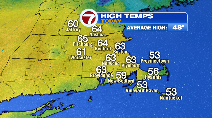
It’s been a warm day around the Bay State! Highs have been 15+ degrees above average! But, after a stunner of an afternoon, we have some big changes to the weather as we head into this Thursday evening.
The first is that, as a cold front moves into New England, we’ll be back in a soggy stretch. Clouds creep in through the late afternoon and early evening before rain arrives, starting around 7 PM in Western Mass, continuing east as the evening goes on.
We’ll be in and out of the rain, some heavy, from then through roughly 4:30 AM Friday morning. For the most part, it’s looking like we’ll see 0.25 – 0.75" of rain within that stretch, though a few outliers on the high side aren’t out of the question where heavier rain sets up.
Timing is on our side with this front, considering the heaviest rain will be after the Thursday evening commute wraps up and before the Friday morning commute begins. As we head into the afternoon clouds decrease… but temperatures do too.
That’s the second major change over the next 36 hours. Friday will be what I like to call an upside-down day– we’ll start mild and end cold, as opposed to the other way around. This is as colder air flies into New England after the cold front passes.
The result will be an afternoon in the low 40s with a stiff breeze out of the north. Bundle up if you’re heading out and about on Friday afternoon/evening, including if you’re going to Polar Park for the Woo Sox Opening Day!
It’ll be (and feel) quite chilly, even for March. While we keep the dry stretch going into the weekend, it will start off chilly as well. The average high for this time of year is in the upper 40s.
Saturday’s highs, despite sunshine, will only be in the upper 30s. We will be back to average on Sunday with highs largely in the upper 40s and a mostly to partly sunny sky. It will be breezier, however, with gusts in the teens and 20s.